Footpath 5 CAI 719 From Canzanica to Monte Bronzone
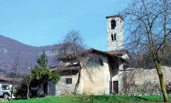
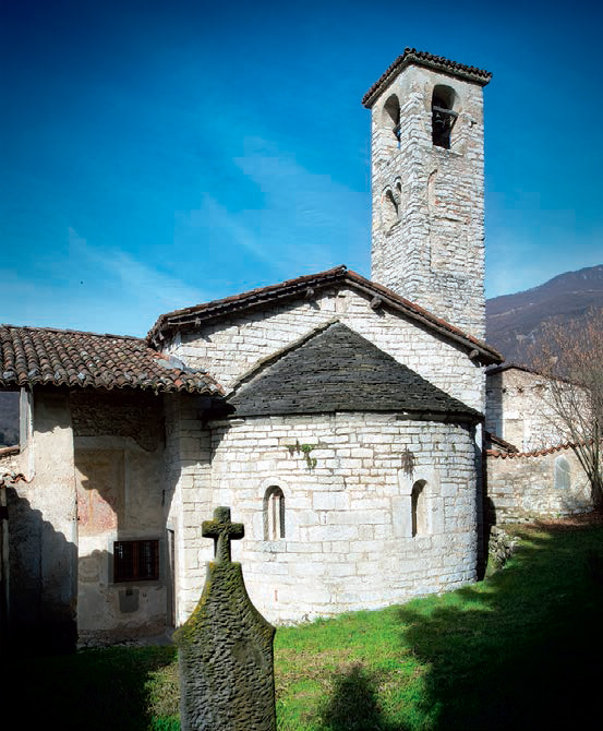
Coming from Villongo on provincial road no.79 (SP79), after Gazzenda and after having passed Adrara San Martino cemetery, you will notice the beautiful Romanesque group of buildings known as Canzanica. Just beyond the bridge, turn right, then turn left after 200m.
Park in front of the church, and you will see the first sign for footpath no.5. Carrying on along the unsurfaced road, you will come across a few houses where the path that flanks the little river begins. Follow the signs and, after about 10 minutes, you will see a wooden bridge.
A bit further on, on your left, you will notice a spring and a grotto with a statue of the Madonna: you are in the area known as “Giardino” (which means “garden”).
Turn right and follow the winding path up the hill: the footpath is supported by dry-stone walls and crosses an Austrian pine wood. Continue up the hill through the pine, hornbeam and birch trees; the path levels out for a short stretch in a beautiful chestnut wood. You are now between Adrara San Martino and Viadanica: there are a few metres of respite, then the path goes up again.
You will have to tackle a fairly steep section. Keep on following the signs and, after about an hour and a half, you will see a signpost. Turn left, following the arrow.
After about 500m you will reach “Cà della Betina” at an altitude of 778 metres. From here you will be able to admire the meadows of the Ducone Alto area, with its farmhouses and the village of Adrara San Rocco; further up is the hamlet of Costa, part of the Adrara San Martino municipality and, further up still, you will see part of the Colli di San Fermo. The signpost here will show you the way for footpath no.701 up to the peak of Monte Bronzone. Alternatively, you can also reach the peak by staying on footpath no.5 and turning right as shown by the other sign. After a few metres you will come to a beautiful meadow known as “Plagna” with a terrace for deerwatching. You will be able to see the plain from here. Following the signs on your left, you follow a nearly flat field to the top, where there is a hunters’ shelter. Go beyond it and carry on through a forest of chestnut, beech and wild cherry trees. You will notice the signpost.
Further on, there is a well that has been restored by hunters for wild animals to drink from. Turn left and the path becomes rocky and, if you look carefully, you’ll notice a beautiful twisted, arched ivy in the shape of a hunter’s bow and a clearing (known as “ral” in the local bergamasco dialect) where the charcoal burners used to make their charcoal.
The footpath becomes fairly level but rockier ahead, and crosses over stones and white rocks. On the left are the meadows and farmhouses of the Foppe area of Bronzone.
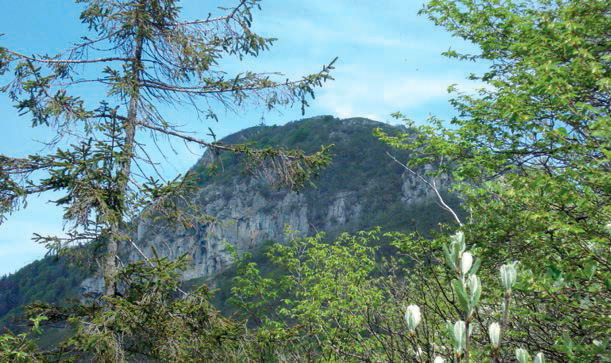
Continue gently upwards. If you look up, you’ll see the ridge of the Bronzone mountain. When you cross path no.701 that comes up from Viadanica on your right, continue left along the ridge following the yellow signs. Just the last stretch to go and you’ll reach the peak, where you will be able to admire the magnificent 360° views.Photos and text by:
Gruppo Sentieri Adrara San Martino e A.S.D Nordic Walking Lago d’Iseo – Paratico
www.grupposentieriadrara.it
Park in front of the church, and you will see the first sign for footpath no.5. Carrying on along the unsurfaced road, you will come across a few houses where the path that flanks the little river begins. Follow the signs and, after about 10 minutes, you will see a wooden bridge.
A bit further on, on your left, you will notice a spring and a grotto with a statue of the Madonna: you are in the area known as “Giardino” (which means “garden”).
Turn right and follow the winding path up the hill: the footpath is supported by dry-stone walls and crosses an Austrian pine wood. Continue up the hill through the pine, hornbeam and birch trees; the path levels out for a short stretch in a beautiful chestnut wood. You are now between Adrara San Martino and Viadanica: there are a few metres of respite, then the path goes up again.
You will have to tackle a fairly steep section. Keep on following the signs and, after about an hour and a half, you will see a signpost. Turn left, following the arrow.
After about 500m you will reach “Cà della Betina” at an altitude of 778 metres. From here you will be able to admire the meadows of the Ducone Alto area, with its farmhouses and the village of Adrara San Rocco; further up is the hamlet of Costa, part of the Adrara San Martino municipality and, further up still, you will see part of the Colli di San Fermo. The signpost here will show you the way for footpath no.701 up to the peak of Monte Bronzone. Alternatively, you can also reach the peak by staying on footpath no.5 and turning right as shown by the other sign. After a few metres you will come to a beautiful meadow known as “Plagna” with a terrace for deerwatching. You will be able to see the plain from here. Following the signs on your left, you follow a nearly flat field to the top, where there is a hunters’ shelter. Go beyond it and carry on through a forest of chestnut, beech and wild cherry trees. You will notice the signpost.
Further on, there is a well that has been restored by hunters for wild animals to drink from. Turn left and the path becomes rocky and, if you look carefully, you’ll notice a beautiful twisted, arched ivy in the shape of a hunter’s bow and a clearing (known as “ral” in the local bergamasco dialect) where the charcoal burners used to make their charcoal.
The footpath becomes fairly level but rockier ahead, and crosses over stones and white rocks. On the left are the meadows and farmhouses of the Foppe area of Bronzone.
Continue gently upwards. If you look up, you’ll see the ridge of the Bronzone mountain. When you cross path no.701 that comes up from Viadanica on your right, continue left along the ridge following the yellow signs. Just the last stretch to go and you’ll reach the peak, where you will be able to admire the magnificent 360° views.Photos and text by:
Gruppo Sentieri Adrara San Martino e A.S.D Nordic Walking Lago d’Iseo – Paratico
www.grupposentieriadrara.it
DETAILS
- Duration:
Up to 4 hours - Elevation gain:
1023 m - Starting point:
Canzanica - Arrival point:
Monte Bronzone - Trail number:
719
Book now:
Treasure hunt in Franciacorta
Franciacorta
A fun experience suitable for everyone in the vineyards of Franciacorta: a team orientation test bet...
 BOOK NOW
Scenic walk to the Big Bench in Franciacorta
Rovato
Among vineyards, woods, and breathtaking views, enjoy an authentic experience in the heart of Franci...
BOOK NOW
Trust the experience of:
×


Scarica i file della mappa
Puoi aprire il file gpx
con l’app outdooractive


